74 reference photographs held (0 with pixels on this page); 1 promoted capture: 1 frame on this page.
The judged home block in Barton Hills, authored palette and all, at golden hour.
30.2460563, -97.786499 · l15 865b4b2b4 · l7 865b4 · ring 2 · sky 17:30 · hero 130 m, pitch 45°, azimuth 250°
stresses: baseline, judged palette-authored home tile
no expected gaps recorded
subjects: Barton Hills home block (the spawn cell) (30.246056, -97.786499)
- street
- 4 street-level frames from Google Street View at headings 70°, 160°, 250°, 340°; 4 from contributor photospheres; 4 found by widening the search to 50 m from the requested point.
- aerial
- no aerial reference; NAIP is public domain (LEGAL-LOG row 'NAIP over Travis county'); labs' gallery https://store-dev.agentarmies.io/labs/demo/index.html; EVAL-15.
- capture
- austin/hero: no promoted ladder row at austin/hero; austin/ground: capture-01m1hpskfd7msmhf6ed19eht7p (harness capture · index-CO0dL_A2.js+health:dev, acquired 2026-09-02)
4 street · 0 aerial · 0 look · 1 captures · 0 unavailable · open the frozen alpha here
Pike Place Market, the steep drop to Pier 62, and Elliott Bay open water in one frame.
47.6094, -122.3417 · l15 54906ab2c · l7 54904 · ring 2 · sky 18:30 · hero 280 m, pitch 45°, azimuth 250°
stresses: hills, water, steep grade to the piers, Elliott Bay
expected gaps: fallback palette; sun ~17° off — solar latitude unfixed
subjects: Pike Place Market (47.609891, -122.342801); Pier 62 waterfront — the foot of the grade (47.608445, -122.344515); Elliott Bay open water (47.6082, -122.3505)
- street
- 4 street-level frames from Google Street View at headings 70°, 160°, 250°, 340°; 4 from contributor photospheres; 4 found by widening the search to 50 m from the requested point.
- aerial
- no aerial reference; NAIP is public domain (LEGAL-LOG row 'NAIP over Travis county'); labs' gallery https://store-dev.agentarmies.io/labs/demo/index.html; EVAL-15.
- capture
- no registered pose for this place; the harness has nothing to capture here yet.
4 street · 0 aerial · 0 look · 0 captures · 0 unavailable
West Beach sand and the harbor's marina edge, seen back off Cabrillo Boulevard.
34.4104, -119.694 · l15 80e9138a4 · l7 80e94 · ring 2 · sky 17:00 · hero 280 m, pitch 45°, azimuth 200°
stresses: coast, ocean datum, shoreline, harbor edge
expected gaps: fallback palette
subjects: West Beach sand (34.4101, -119.6906); Santa Barbara Harbor marina edge (Marina D) (34.407098, -119.692406)
- street
- 4 street-level frames from Google Street View at headings 20°, 110°, 200°, 290°; 4 from contributor photospheres; 4 found by widening the search to 50 m from the requested point.
- aerial
- no aerial reference; NAIP is public domain (LEGAL-LOG row 'NAIP over Travis county'); labs' gallery https://store-dev.agentarmies.io/labs/demo/index.html; EVAL-15.
- capture
- no registered pose for this place; the harness has nothing to capture here yet.
4 street · 0 aerial · 0 look · 0 captures · 0 unavailable
Bryant Park as a green hole in the Midtown canyon, the library on one side and the towers on the other.
40.7536, -73.9832 · l15 89c259aac · l7 89c24 · ring 2 · sky 09:30 · hero 525 m, pitch 45°, azimuth 40°
stresses: towers, bodies, extreme density, tall shells, park-in-grid
expected gaps: tower shells from RAW heights; fallback facades · cure: 3DEP jobspec
subjects: Bryant Park lawn (40.75365, -73.98325); One Bryant Park (Bank of America Tower) (40.75551, -73.98465); New York Public Library, Schwarzman Building (40.75318, -73.98211)
- street
- 4 street-level frames from Google Street View at headings 40°, 130°, 220°, 310°; 4 from contributor photospheres; 4 found by widening the search to 50 m from the requested point.
- aerial
- no aerial reference; NAIP is public domain (LEGAL-LOG row 'NAIP over Travis county'); labs' gallery https://store-dev.agentarmies.io/labs/demo/index.html; EVAL-15.
- capture
- no registered pose for this place; the harness has nothing to capture here yet.
4 street · 0 aerial · 0 look · 0 captures · 0 unavailable
Across Westminster Bridge to Parliament, with the Thames running under it.
51.5007, -0.122 · l15 487604c6c · l7 48764 · ring 2 · sky 16:00 · hero 525 m, pitch 45°, azimuth 260°
stresses: river, bridges, non-US data, Thames as a BODY, UK OSM idioms
expected gaps: flat terrain — elevation unacquired; Thames reads flat — no tidal row; Austin palette; sun ~17° off — solar latitude unfixed · cure: planet clip 48764
subjects: Palace of Westminster — Elizabeth Tower (51.50073, -0.12464); Palace of Westminster — Victoria Tower (~350 m) (51.4979, -0.1249); Westminster Bridge deck (51.50085, -0.12153); River Thames channel at the bridge (51.501, -0.123)
- street
- 4 street-level frames from Google Street View at headings 80°, 170°, 260°, 350°; 4 from contributor photospheres; 4 found by widening the search to 50 m from the requested point.
- aerial
- no aerial reference; NAIP is public domain (LEGAL-LOG row 'NAIP over Travis county'); labs' gallery https://store-dev.agentarmies.io/labs/demo/index.html; EVAL-15.
- capture
- no registered pose for this place; the harness has nothing to capture here yet.
4 street · 0 aerial · 0 look · 0 captures · 0 unavailable
The Cook's Meadow floor at the foot of the valley walls, the Merced running east to Sentinel Bridge.
37.7456, -119.5936 · l15 8096f202c · l7 8096c · ring 3 · sky 08:30 · hero 525 m, pitch 45°, azimuth 90°
stresses: terrain, nature, real relief, no urban grid, species palette
expected gaps: broadleaf stand-ins for conifers; upper walls beyond the baked ring — horizon empty · cure: DEM window unarmed
subjects: Cook's Meadow floor (37.7456, -119.5936); Merced River at Sentinel Bridge (37.7461, -119.5872); North wall base below Yosemite Falls (37.7497, -119.5962)
- street
- 4 street-level frames from Google Street View at headings 0°, 90°, 180°, 270°; 4 from contributor photospheres; 4 found by widening the search to 50 m from the requested point.
- aerial
- no aerial reference; NAIP is public domain (LEGAL-LOG row 'NAIP over Travis county'); labs' gallery https://store-dev.agentarmies.io/labs/demo/index.html; EVAL-15.
- capture
- no registered pose for this place; the harness has nothing to capture here yet.
4 street · 0 aerial · 0 look · 0 captures · 0 unavailable
Sparkman Wharf and the Channelside waterfront where the port meets downtown Tampa.
27.94237, -82.4484 · l15 88c2c4f24 · l7 88c2c · ring 2 · sky 18:30 · hero 180 m, pitch 45°, azimuth 250°
stresses: urban waterfront, port cranes, bay water
expected gaps: demand-clip species palette is generic pending the region pass
subjects: Sparkman Wharf waterfront (27.94237, -82.4484)
- street
- 4 street-level frames from Google Street View at headings 70°, 160°, 250°, 340°; 4 found by widening the search to 50 m from the requested point.
- aerial
- no aerial reference; NAIP is public domain (LEGAL-LOG row 'NAIP over Travis county'); labs' gallery https://store-dev.agentarmies.io/labs/demo/index.html; EVAL-15.
- capture
- no registered pose for this place; the harness has nothing to capture here yet.
4 street · 0 aerial · 0 look · 0 captures · 0 unavailable
Gallery Plaza on Ponce de León Avenue, the Santurce arts blocks around it.
18.45107, -66.06592 · l15 8c036f494 · l7 8c034 · ring 2 · sky 17:00 · hero 150 m, pitch 45°, azimuth 200°
stresses: tropical urban, mid-rise fabric, caribbean light
expected gaps: demand-clip species palette is generic pending the region pass
subjects: Gallery Plaza, Santurce (18.45107, -66.06592)
- street
- 4 street-level frames from Google Street View at headings 20°, 110°, 200°, 290°; 4 found by widening the search to 50 m from the requested point.
- aerial
- no aerial reference; NAIP is public domain (LEGAL-LOG row 'NAIP over Travis county'); labs' gallery https://store-dev.agentarmies.io/labs/demo/index.html; EVAL-15.
- capture
- no registered pose for this place; the harness has nothing to capture here yet.
4 street · 0 aerial · 0 look · 0 captures · 0 unavailable
The East Course fairways running to the Atlantic at Dorado Beach.
18.4629, -66.28387 · l15 8c031487c · l7 8c034 · ring 3 · sky 08:00 · hero 260 m, pitch 40°, azimuth 340°
stresses: golf turf, coastal palms, manicured ground
expected gaps: fairway/rough/green turf classes not yet in the demand-clip solver (the ground harness's dorado-east-1m DEM window covers this ground)
subjects: East Course oceanside fairways (18.4629, -66.28387)
- street
- 4 street-level frames from Google Street View at headings 70°, 160°, 250°, 340°; 4 found by widening the search to 200 m from the requested point; 4 headings answered ZERO_RESULTS at the requested point.
- aerial
- no aerial reference; NAIP is public domain (LEGAL-LOG row 'NAIP over Travis county'); labs' gallery https://store-dev.agentarmies.io/labs/demo/index.html; EVAL-15.
- capture
- no registered pose for this place; the harness has nothing to capture here yet.
4 street · 0 aerial · 0 look · 0 captures · 4 unavailable
South Pointe Park at the tip of Miami Beach, Government Cut and the cruise channel beside it.
25.76545, -80.13414 · l15 88d9b4f04 · l7 88d9c · ring 2 · sky 18:00 · hero 200 m, pitch 45°, azimuth 300°
stresses: beach, park turf, high-rise skyline, channel water
expected gaps: demand-clip species palette is generic pending the region pass
subjects: South Pointe Park and pier (25.76545, -80.13414)
- street
- 4 street-level frames from Google Street View at headings 30°, 120°, 210°, 300°; 4 found by widening the search to 50 m from the requested point.
- aerial
- no aerial reference; NAIP is public domain (LEGAL-LOG row 'NAIP over Travis county'); labs' gallery https://store-dev.agentarmies.io/labs/demo/index.html; EVAL-15.
- capture
- no registered pose for this place; the harness has nothing to capture here yet.
4 street · 0 aerial · 0 look · 0 captures · 0 unavailable
Hopi Point on the West Rim Drive — the widest sunset panorama on the South Rim, the river visible a mile below.
36.07374, -112.15525 · l15 87331727c · l7 87334 · ring 3 · sky 18:45 · hero 600 m, pitch 30°, azimuth 20°
stresses: terrain, real relief, canyon depth, no urban grid
expected gaps: canyon relief is the whole subject — flat until the demand-clip elevation datum lands · cure: planet-clip elevation datum (demand clips compile flat-unacquired today)
subjects: Hopi Point rim overlook (36.07374, -112.15525)
- street
- 4 street-level frames from Google Street View at headings 20°, 110°, 200°, 290°; 4 found by widening the search to 50 m from the requested point.
- aerial
- no aerial reference; NAIP is public domain (LEGAL-LOG row 'NAIP over Travis county'); labs' gallery https://store-dev.agentarmies.io/labs/demo/index.html; EVAL-15.
- capture
- no registered pose for this place; the harness has nothing to capture here yet.
4 street · 0 aerial · 0 look · 0 captures · 0 unavailable
The town terraces above Lake St. Moritz, the Engadin peaks behind.
46.4983, 9.8385 · l15 47837deac · l7 47834 · ring 3 · sky 09:00 · hero 420 m, pitch 35°, azimuth 140°
stresses: alpine terrain, lake, resort town fabric
expected gaps: alpine relief flat until the demand-clip elevation datum lands; conifer register pending NATURE-2 · cure: planet-clip elevation datum (demand clips compile flat-unacquired today)
subjects: Lakefront below the town (46.4956, 9.8421)
- street
- 4 street-level frames from Google Street View at headings 50°, 140°, 230°, 320°; 4 from contributor photospheres; 4 found by widening the search to 50 m from the requested point.
- aerial
- no aerial reference; NAIP is public domain (LEGAL-LOG row 'NAIP over Travis county'); labs' gallery https://store-dev.agentarmies.io/labs/demo/index.html; EVAL-15.
- capture
- no registered pose for this place; the harness has nothing to capture here yet.
4 street · 0 aerial · 0 look · 0 captures · 0 unavailable
Gion's machiya blocks meeting the Kamo River at Shijō Bridge.
35.00365, 135.77519 · l15 600108c1c · l7 60014 · ring 2 · sky 17:30 · hero 160 m, pitch 45°, azimuth 270°
stresses: traditional low-rise fabric, river, dense street grid
expected gaps: machiya roof forms need their own asset class — generic buildings today
subjects: Shijō Bridge over the Kamo (35.00365, 135.77519)
- street
- 4 street-level frames from Google Street View at headings 0°, 90°, 180°, 270°; 4 from contributor photospheres; 4 found by widening the search to 50 m from the requested point.
- aerial
- no aerial reference; NAIP is public domain (LEGAL-LOG row 'NAIP over Travis county'); labs' gallery https://store-dev.agentarmies.io/labs/demo/index.html; EVAL-15.
- capture
- no registered pose for this place; the harness has nothing to capture here yet.
4 street · 0 aerial · 0 look · 0 captures · 0 unavailable
The crater rim at Uhuru Peak at dawn, the last glaciers and the cloud sea below.
-3.06764, 37.3555 · l15 1839fc5b4 · l7 1839c · ring 3 · sky 06:30 · hero 700 m, pitch 25°, azimuth 90°
stresses: extreme elevation, glacier remnants, above-cloud horizon
expected gaps: the mountain IS relief — flat until the demand-clip elevation datum lands · cure: planet-clip elevation datum (demand clips compile flat-unacquired today)
subjects: Uhuru Peak crater rim (-3.06764, 37.3555)
- street
- 4 street-level frames from Google Street View at headings 0°, 90°, 180°, 270°; 4 from contributor photospheres; 4 found by widening the search to 50 m from the requested point.
- aerial
- no aerial reference; NAIP is public domain (LEGAL-LOG row 'NAIP over Travis county'); labs' gallery https://store-dev.agentarmies.io/labs/demo/index.html; EVAL-15.
- capture
- no registered pose for this place; the harness has nothing to capture here yet.
4 street · 0 aerial · 0 look · 0 captures · 0 unavailable
Waikiki Beach with Diamond Head closing the bay to the east.
21.27492, -157.82563 · l15 7c007276c · l7 7c004 · ring 2 · sky 17:45 · hero 220 m, pitch 40°, azimuth 120°
stresses: beach, resort towers, ocean water, volcanic backdrop
expected gaps: Diamond Head silhouette flat until the demand-clip elevation datum lands
subjects: Waikiki shore (21.27492, -157.82563)
- street
- 4 street-level frames from Google Street View at headings 30°, 120°, 210°, 300°; 4 found by widening the search to 50 m from the requested point.
- aerial
- no aerial reference; NAIP is public domain (LEGAL-LOG row 'NAIP over Travis county'); labs' gallery https://store-dev.agentarmies.io/labs/demo/index.html; EVAL-15.
- capture
- no registered pose for this place; the harness has nothing to capture here yet.
4 street · 0 aerial · 0 look · 0 captures · 0 unavailable
The Trocadéro esplanade looking across the Seine to the Eiffel Tower.
48.86184, 2.2892 · l15 47e66fe34 · l7 47e64 · ring 3 · sky 18:30 · hero 320 m, pitch 35°, azimuth 130°
stresses: monument, formal urban axis, river
expected gaps: the tower's lattice needs a landmark-grade mesh — extruded OSM footprint today
subjects: Trocadéro esplanade (48.86184, 2.2892); Eiffel Tower (48.85837, 2.29448)
- street
- 4 street-level frames from Google Street View at headings 40°, 130°, 220°, 310°; 4 found by widening the search to 50 m from the requested point.
- aerial
- no aerial reference; NAIP is public domain (LEGAL-LOG row 'NAIP over Travis county'); labs' gallery https://store-dev.agentarmies.io/labs/demo/index.html; EVAL-15.
- capture
- no registered pose for this place; the harness has nothing to capture here yet.
4 street · 0 aerial · 0 look · 0 captures · 0 unavailable
The Ferry Building and the Embarcadero, the bay bridge line behind.
37.79546, -122.39359 · l15 80858066c · l7 8085c · ring 2 · sky 17:00 · hero 180 m, pitch 45°, azimuth 235°
stresses: waterfront, dense downtown, hills behind
expected gaps: street grade on the hills flat until the demand-clip elevation datum lands
subjects: Ferry Building clock tower (37.79546, -122.39359)
- street
- 4 street-level frames from Google Street View at headings 55°, 145°, 235°, 325°; 4 from contributor photospheres; 4 found by widening the search to 50 m from the requested point.
- aerial
- no aerial reference; NAIP is public domain (LEGAL-LOG row 'NAIP over Travis county'); labs' gallery https://store-dev.agentarmies.io/labs/demo/index.html; EVAL-15.
- capture
- no registered pose for this place; the harness has nothing to capture here yet.
4 street · 0 aerial · 0 look · 0 captures · 0 unavailable
internal
internal-only: pixels on the internal view; LEGAL-LOG row 'Google Street View imagery'.
db4b847de557a7b5…
streetinternalofficial
Google Street View at Dorado Beach — East Course: heading 340°, pitch 0°, fov 70°, captured 2025-04, © Google.
Dorado Beach — East Course · acquired 2026-09-03 · captured 2025-04 · 640×640
Google Maps Platform Terms · credit: © Google · internal (LEGAL-LOG row 'Google Street View imagery', conditions: attribution; no-public-hosting): pixels on the internal view only.
detail
internal
internal-only: pixels on the internal view; LEGAL-LOG row 'Google Street View imagery'.
bf6a8544456c1e65…
streetinternalofficial
Google Street View at Dorado Beach — East Course: heading 70°, pitch 0°, fov 70°, captured 2025-04, © Google.
Dorado Beach — East Course · acquired 2026-09-03 · captured 2025-04 · 640×640
Google Maps Platform Terms · credit: © Google · internal (LEGAL-LOG row 'Google Street View imagery', conditions: attribution; no-public-hosting): pixels on the internal view only.
detail
internal
internal-only: pixels on the internal view; LEGAL-LOG row 'Google Street View imagery'.
62482fc5e70647ce…
streetinternalofficial
Google Street View at Dorado Beach — East Course: heading 160°, pitch 0°, fov 70°, captured 2025-04, © Google.
Dorado Beach — East Course · acquired 2026-09-03 · captured 2025-04 · 640×640
Google Maps Platform Terms · credit: © Google · internal (LEGAL-LOG row 'Google Street View imagery', conditions: attribution; no-public-hosting): pixels on the internal view only.
detail
internal
internal-only: pixels on the internal view; LEGAL-LOG row 'Google Street View imagery'.
7b650b227f7f3848…
streetinternalofficial
Google Street View at Dorado Beach — East Course: heading 250°, pitch 0°, fov 70°, captured 2025-04, © Google.
Dorado Beach — East Course · acquired 2026-09-03 · captured 2025-04 · 640×640
Google Maps Platform Terms · credit: © Google · internal (LEGAL-LOG row 'Google Street View imagery', conditions: attribution; no-public-hosting): pixels on the internal view only.
detail
internal
internal-only: pixels on the internal view; LEGAL-LOG row 'GTA5 reference captures (the ladder's rungs)'.
03368705c52bce6e…
lookinternalgta5-groundlook only
Eye-height third-person street shot in a low-rise commercial block: sidewalk grime, chain-link, a brick wall and a paved yard as the bar for near-field material density; the protagonist and HUD are outside clean_box.
unplaced · acquired 2026-09-02 · captured unknown · 1920×1080
proprietary (Rockstar Games); reference only · internal (LEGAL-LOG row 'GTA5 reference captures (the ladder's rungs)', conditions: no-public-hosting): pixels on the internal view only.
detail
internal
internal-only: pixels on the internal view; LEGAL-LOG row 'GTA5 reference captures (the ladder's rungs)'.
a677915bef6c51e6…
lookinternalgta5-groundlook only
Eye-height third-person boulevard shot: lawn, parking meters, a parked sedan and towers behind palms as the bar for near-field richness and midday lighting; the protagonist and banners are outside clean_box.
unplaced · acquired 2026-09-02 · captured unknown · 1280×720
proprietary (Rockstar Games); reference only · internal (LEGAL-LOG row 'GTA5 reference captures (the ladder's rungs)', conditions: no-public-hosting): pixels on the internal view only.
detail
internal
internal-only: pixels on the internal view; LEGAL-LOG row 'GTA5 reference captures (the ladder's rungs)'.
9506aac2c455e025…
lookinternalgta5-groundlook only
Elevated eye-height shot over a desert valley: far-field terrain, sparse trees and a road grid as the bar for distant placement density and haze; the protagonist and HUD are outside clean_box.
unplaced · acquired 2026-09-02 · captured unknown · 1500×843
proprietary (Rockstar Games); reference only · internal (LEGAL-LOG row 'GTA5 reference captures (the ladder's rungs)', conditions: no-public-hosting): pixels on the internal view only.
detail
internal
internal-only: pixels on the internal view; LEGAL-LOG row 'GTA5 reference captures (the ladder's rungs)'.
2318b3499d14270b…
lookinternalgta5-ground
Eye-height forest trail with no character in frame: needle litter, flowering understorey and backlit conifers as the bar for ground-level material density and golden-hour lighting.
unplaced · acquired 2026-09-02 · captured unknown · 1080×607
proprietary (Rockstar Games); reference only · internal (LEGAL-LOG row 'GTA5 reference captures (the ladder's rungs)', conditions: no-public-hosting): pixels on the internal view only.
detail
internal
internal-only: pixels on the internal view; LEGAL-LOG row 'GTA5 reference captures (the ladder's rungs)'.
1dea1704b2334223…
lookinternalgta5-ground
Elevated beach shot with no protagonist: stilt houses, rocks, crowded sand and surf as the bar for placement density, water contact and midday lighting; the logo paste is outside clean_box.
unplaced · acquired 2026-09-02 · captured unknown · 1100×619
proprietary (Rockstar Games); reference only · internal (LEGAL-LOG row 'GTA5 reference captures (the ladder's rungs)', conditions: no-public-hosting): pixels on the internal view only.
detail
internal
internal-only: pixels on the internal view; LEGAL-LOG row 'GTA5 reference captures (the ladder's rungs)'.
57421177e5594481…
lookinternalgta5-groundlook only
Eye-height third-person intersection shot: wet asphalt, a crosswalk, a parked coupe and a plaza facade as the bar for near-field road material and low-sun lighting; the protagonist and HUD are outside clean_box.
unplaced · acquired 2026-09-02 · captured unknown · 1280×720
proprietary (Rockstar Games); reference only · internal (LEGAL-LOG row 'GTA5 reference captures (the ladder's rungs)', conditions: no-public-hosting): pixels on the internal view only.
detail
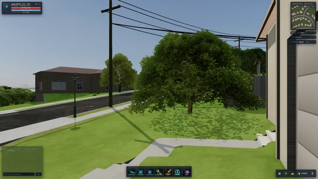
capturepublic-okalpha-frozenHUD visible
The floor: the frozen alpha (build index-CO0dL_A2.js+health:dev) captured by the harness at austin/ground; every later build at this pose is judged against it.
Austin — Barton Hills · acquired 2026-09-02 · captured 2026-09-02 · 2560×1440
own-work · public-ok (LEGAL-LOG row 'the frozen alpha', conditions: other:"not a publisher declaration; no public object may resolve only to this row"): pixels on this page.
detail
internal
internal-only: pixels on the internal view; LEGAL-LOG row 'Google Street View imagery'.
d993eab25abc986f…
streetinternalphotosphere
Google Street View at Austin — Barton Hills: heading 250°, pitch 0°, fov 70°, captured 2025-07, © Jacob Perkins.
Austin — Barton Hills · acquired 2026-09-02 · captured 2025-07 · 640×640
Google Maps Platform Terms · credit: © Jacob Perkins · internal (LEGAL-LOG row 'Google Street View imagery', conditions: attribution; no-public-hosting): pixels on the internal view only.
detail
internal
internal-only: pixels on the internal view; LEGAL-LOG row 'Google Street View imagery'.
2db61d637ccc3907…
streetinternalphotosphere
Google Street View at Austin — Barton Hills: heading 340°, pitch 0°, fov 70°, captured 2025-07, © Jacob Perkins.
Austin — Barton Hills · acquired 2026-09-02 · captured 2025-07 · 640×640
Google Maps Platform Terms · credit: © Jacob Perkins · internal (LEGAL-LOG row 'Google Street View imagery', conditions: attribution; no-public-hosting): pixels on the internal view only.
detail
internal
internal-only: pixels on the internal view; LEGAL-LOG row 'Google Street View imagery'.
82b915da75d76cbd…
streetinternalphotosphere
Google Street View at Austin — Barton Hills: heading 70°, pitch 0°, fov 70°, captured 2025-07, © Jacob Perkins.
Austin — Barton Hills · acquired 2026-09-02 · captured 2025-07 · 640×640
Google Maps Platform Terms · credit: © Jacob Perkins · internal (LEGAL-LOG row 'Google Street View imagery', conditions: attribution; no-public-hosting): pixels on the internal view only.
detail
internal
internal-only: pixels on the internal view; LEGAL-LOG row 'Google Street View imagery'.
f5c14f89d55902de…
streetinternalphotosphere
Google Street View at Austin — Barton Hills: heading 160°, pitch 0°, fov 70°, captured 2025-07, © Jacob Perkins.
Austin — Barton Hills · acquired 2026-09-02 · captured 2025-07 · 640×640
Google Maps Platform Terms · credit: © Jacob Perkins · internal (LEGAL-LOG row 'Google Street View imagery', conditions: attribution; no-public-hosting): pixels on the internal view only.
detail
internal
internal-only: pixels on the internal view; LEGAL-LOG row 'Google Street View imagery'.
fbdbf9db5f622997…
streetinternalphotosphere
Google Street View at Seattle — Pike Place: heading 250°, pitch 0°, fov 70°, captured 2016-09, © Ben Konrady.
Seattle — Pike Place · acquired 2026-09-02 · captured 2016-09 · 640×640
Google Maps Platform Terms · credit: © Ben Konrady · internal (LEGAL-LOG row 'Google Street View imagery', conditions: attribution; no-public-hosting): pixels on the internal view only.
detail
internal
internal-only: pixels on the internal view; LEGAL-LOG row 'Google Street View imagery'.
7e94233e9dad8f2a…
streetinternalphotosphere
Google Street View at Seattle — Pike Place: heading 340°, pitch 0°, fov 70°, captured 2016-09, © Ben Konrady.
Seattle — Pike Place · acquired 2026-09-02 · captured 2016-09 · 640×640
Google Maps Platform Terms · credit: © Ben Konrady · internal (LEGAL-LOG row 'Google Street View imagery', conditions: attribution; no-public-hosting): pixels on the internal view only.
detail
internal
internal-only: pixels on the internal view; LEGAL-LOG row 'Google Street View imagery'.
97372ec383c7a313…
streetinternalphotosphere
Google Street View at Seattle — Pike Place: heading 70°, pitch 0°, fov 70°, captured 2016-09, © Ben Konrady.
Seattle — Pike Place · acquired 2026-09-02 · captured 2016-09 · 640×640
Google Maps Platform Terms · credit: © Ben Konrady · internal (LEGAL-LOG row 'Google Street View imagery', conditions: attribution; no-public-hosting): pixels on the internal view only.
detail
internal
internal-only: pixels on the internal view; LEGAL-LOG row 'Google Street View imagery'.
0224da31f7b11a0b…
streetinternalphotosphere
Google Street View at Seattle — Pike Place: heading 160°, pitch 0°, fov 70°, captured 2016-09, © Ben Konrady.
Seattle — Pike Place · acquired 2026-09-02 · captured 2016-09 · 640×640
Google Maps Platform Terms · credit: © Ben Konrady · internal (LEGAL-LOG row 'Google Street View imagery', conditions: attribution; no-public-hosting): pixels on the internal view only.
detail
internal
internal-only: pixels on the internal view; LEGAL-LOG row 'Google Street View imagery'.
72b640c2d6706851…
streetinternalphotosphere
Google Street View at Santa Barbara — West Beach: heading 200°, pitch 0°, fov 70°, captured 2022-08, © Nick Moody.
Santa Barbara — West Beach · acquired 2026-09-02 · captured 2022-08 · 640×640
Google Maps Platform Terms · credit: © Nick Moody · internal (LEGAL-LOG row 'Google Street View imagery', conditions: attribution; no-public-hosting): pixels on the internal view only.
detail
internal
internal-only: pixels on the internal view; LEGAL-LOG row 'Google Street View imagery'.
60ea33e968381acc…
streetinternalphotosphere
Google Street View at Santa Barbara — West Beach: heading 290°, pitch 0°, fov 70°, captured 2022-08, © Nick Moody.
Santa Barbara — West Beach · acquired 2026-09-02 · captured 2022-08 · 640×640
Google Maps Platform Terms · credit: © Nick Moody · internal (LEGAL-LOG row 'Google Street View imagery', conditions: attribution; no-public-hosting): pixels on the internal view only.
detail
internal
internal-only: pixels on the internal view; LEGAL-LOG row 'Google Street View imagery'.
c2c600b977ea0e94…
streetinternalphotosphere
Google Street View at Santa Barbara — West Beach: heading 20°, pitch 0°, fov 70°, captured 2022-08, © Nick Moody.
Santa Barbara — West Beach · acquired 2026-09-02 · captured 2022-08 · 640×640
Google Maps Platform Terms · credit: © Nick Moody · internal (LEGAL-LOG row 'Google Street View imagery', conditions: attribution; no-public-hosting): pixels on the internal view only.
detail
internal
internal-only: pixels on the internal view; LEGAL-LOG row 'Google Street View imagery'.
8bd1701f6847ccf6…
streetinternalphotosphere
Google Street View at Santa Barbara — West Beach: heading 110°, pitch 0°, fov 70°, captured 2022-08, © Nick Moody.
Santa Barbara — West Beach · acquired 2026-09-02 · captured 2022-08 · 640×640
Google Maps Platform Terms · credit: © Nick Moody · internal (LEGAL-LOG row 'Google Street View imagery', conditions: attribution; no-public-hosting): pixels on the internal view only.
detail
internal
internal-only: pixels on the internal view; LEGAL-LOG row 'Google Street View imagery'.
ef181ac87d015854…
streetinternalphotosphere
Google Street View at Manhattan — Bryant Park: heading 40°, pitch 0°, fov 70°, captured 2022-05, © Coby Walker.
Manhattan — Bryant Park · acquired 2026-09-02 · captured 2022-05 · 640×640
Google Maps Platform Terms · credit: © Coby Walker · internal (LEGAL-LOG row 'Google Street View imagery', conditions: attribution; no-public-hosting): pixels on the internal view only.
detail
internal
internal-only: pixels on the internal view; LEGAL-LOG row 'Google Street View imagery'.
bfa3279165981231…
streetinternalphotosphere
Google Street View at Manhattan — Bryant Park: heading 130°, pitch 0°, fov 70°, captured 2022-05, © Coby Walker.
Manhattan — Bryant Park · acquired 2026-09-02 · captured 2022-05 · 640×640
Google Maps Platform Terms · credit: © Coby Walker · internal (LEGAL-LOG row 'Google Street View imagery', conditions: attribution; no-public-hosting): pixels on the internal view only.
detail
internal
internal-only: pixels on the internal view; LEGAL-LOG row 'Google Street View imagery'.
47f377821e3b9768…
streetinternalphotosphere
Google Street View at Manhattan — Bryant Park: heading 220°, pitch 0°, fov 70°, captured 2022-05, © Coby Walker.
Manhattan — Bryant Park · acquired 2026-09-02 · captured 2022-05 · 640×640
Google Maps Platform Terms · credit: © Coby Walker · internal (LEGAL-LOG row 'Google Street View imagery', conditions: attribution; no-public-hosting): pixels on the internal view only.
detail
internal
internal-only: pixels on the internal view; LEGAL-LOG row 'Google Street View imagery'.
45056929bbf2db9c…
streetinternalphotosphere
Google Street View at Manhattan — Bryant Park: heading 310°, pitch 0°, fov 70°, captured 2022-05, © Coby Walker.
Manhattan — Bryant Park · acquired 2026-09-02 · captured 2022-05 · 640×640
Google Maps Platform Terms · credit: © Coby Walker · internal (LEGAL-LOG row 'Google Street View imagery', conditions: attribution; no-public-hosting): pixels on the internal view only.
detail
internal
internal-only: pixels on the internal view; LEGAL-LOG row 'Google Street View imagery'.
b7dbfe5e84c20686…
streetinternalphotosphere
Google Street View at London — South Bank: heading 260°, pitch 0°, fov 70°, captured 2025-02, © Roman Salčák.
London — South Bank · acquired 2026-09-02 · captured 2025-02 · 640×640
Google Maps Platform Terms · credit: © Roman Salčák · internal (LEGAL-LOG row 'Google Street View imagery', conditions: attribution; no-public-hosting): pixels on the internal view only.
detail
internal
internal-only: pixels on the internal view; LEGAL-LOG row 'Google Street View imagery'.
47158bfd830ce84d…
streetinternalphotosphere
Google Street View at London — South Bank: heading 350°, pitch 0°, fov 70°, captured 2025-02, © Roman Salčák.
London — South Bank · acquired 2026-09-02 · captured 2025-02 · 640×640
Google Maps Platform Terms · credit: © Roman Salčák · internal (LEGAL-LOG row 'Google Street View imagery', conditions: attribution; no-public-hosting): pixels on the internal view only.
detail
internal
internal-only: pixels on the internal view; LEGAL-LOG row 'Google Street View imagery'.
449ac9454cc2d7a9…
streetinternalphotosphere
Google Street View at London — South Bank: heading 80°, pitch 0°, fov 70°, captured 2025-02, © Roman Salčák.
London — South Bank · acquired 2026-09-02 · captured 2025-02 · 640×640
Google Maps Platform Terms · credit: © Roman Salčák · internal (LEGAL-LOG row 'Google Street View imagery', conditions: attribution; no-public-hosting): pixels on the internal view only.
detail
internal
internal-only: pixels on the internal view; LEGAL-LOG row 'Google Street View imagery'.
251aa2267cb1ba92…
streetinternalphotosphere
Google Street View at London — South Bank: heading 170°, pitch 0°, fov 70°, captured 2025-02, © Roman Salčák.
London — South Bank · acquired 2026-09-02 · captured 2025-02 · 640×640
Google Maps Platform Terms · credit: © Roman Salčák · internal (LEGAL-LOG row 'Google Street View imagery', conditions: attribution; no-public-hosting): pixels on the internal view only.
detail
internal
internal-only: pixels on the internal view; LEGAL-LOG row 'Google Street View imagery'.
1733ca713ebe3185…
streetinternalphotosphere
Google Street View at Yosemite — Cook's Meadow: heading 90°, pitch 0°, fov 70°, captured 2025-08, © Jojo.
Yosemite — Cook's Meadow · acquired 2026-09-02 · captured 2025-08 · 640×640
Google Maps Platform Terms · credit: © Jojo · internal (LEGAL-LOG row 'Google Street View imagery', conditions: attribution; no-public-hosting): pixels on the internal view only.
detail
internal
internal-only: pixels on the internal view; LEGAL-LOG row 'Google Street View imagery'.
38af44d567a7020e…
streetinternalphotosphere
Google Street View at Yosemite — Cook's Meadow: heading 180°, pitch 0°, fov 70°, captured 2025-08, © Jojo.
Yosemite — Cook's Meadow · acquired 2026-09-02 · captured 2025-08 · 640×640
Google Maps Platform Terms · credit: © Jojo · internal (LEGAL-LOG row 'Google Street View imagery', conditions: attribution; no-public-hosting): pixels on the internal view only.
detail
internal
internal-only: pixels on the internal view; LEGAL-LOG row 'Google Street View imagery'.
0968a017dedf9b53…
streetinternalphotosphere
Google Street View at Yosemite — Cook's Meadow: heading 270°, pitch 0°, fov 70°, captured 2025-08, © Jojo.
Yosemite — Cook's Meadow · acquired 2026-09-02 · captured 2025-08 · 640×640
Google Maps Platform Terms · credit: © Jojo · internal (LEGAL-LOG row 'Google Street View imagery', conditions: attribution; no-public-hosting): pixels on the internal view only.
detail
internal
internal-only: pixels on the internal view; LEGAL-LOG row 'Google Street View imagery'.
c7250b7bf354dcd1…
streetinternalphotosphere
Google Street View at Yosemite — Cook's Meadow: heading 0°, pitch 0°, fov 70°, captured 2025-08, © Jojo.
Yosemite — Cook's Meadow · acquired 2026-09-02 · captured 2025-08 · 640×640
Google Maps Platform Terms · credit: © Jojo · internal (LEGAL-LOG row 'Google Street View imagery', conditions: attribution; no-public-hosting): pixels on the internal view only.
detail
internal
internal-only: pixels on the internal view; LEGAL-LOG row 'Google Street View imagery'.
0c8a6d5ac9ec87dd…
streetinternalofficial
Google Street View at Tampa — Channelside: heading 250°, pitch 0°, fov 70°, captured 2022-06, © Google.
Tampa — Channelside · acquired 2026-09-02 · captured 2022-06 · 640×640
Google Maps Platform Terms · credit: © Google · internal (LEGAL-LOG row 'Google Street View imagery', conditions: attribution; no-public-hosting): pixels on the internal view only.
detail
internal
internal-only: pixels on the internal view; LEGAL-LOG row 'Google Street View imagery'.
d6ae77db6ae20f97…
streetinternalofficial
Google Street View at Tampa — Channelside: heading 340°, pitch 0°, fov 70°, captured 2022-06, © Google.
Tampa — Channelside · acquired 2026-09-02 · captured 2022-06 · 640×640
Google Maps Platform Terms · credit: © Google · internal (LEGAL-LOG row 'Google Street View imagery', conditions: attribution; no-public-hosting): pixels on the internal view only.
detail
internal
internal-only: pixels on the internal view; LEGAL-LOG row 'Google Street View imagery'.
c8067d5d954e3a98…
streetinternalofficial
Google Street View at Tampa — Channelside: heading 70°, pitch 0°, fov 70°, captured 2022-06, © Google.
Tampa — Channelside · acquired 2026-09-02 · captured 2022-06 · 640×640
Google Maps Platform Terms · credit: © Google · internal (LEGAL-LOG row 'Google Street View imagery', conditions: attribution; no-public-hosting): pixels on the internal view only.
detail
internal
internal-only: pixels on the internal view; LEGAL-LOG row 'Google Street View imagery'.
f42db57768dbe838…
streetinternalofficial
Google Street View at Tampa — Channelside: heading 160°, pitch 0°, fov 70°, captured 2022-06, © Google.
Tampa — Channelside · acquired 2026-09-02 · captured 2022-06 · 640×640
Google Maps Platform Terms · credit: © Google · internal (LEGAL-LOG row 'Google Street View imagery', conditions: attribution; no-public-hosting): pixels on the internal view only.
detail
internal
internal-only: pixels on the internal view; LEGAL-LOG row 'Google Street View imagery'.
e3f2202b17be3048…
streetinternalofficial
Google Street View at San Juan — Gallery Plaza: heading 200°, pitch 0°, fov 70°, captured 2024-12, © Google.
San Juan — Gallery Plaza · acquired 2026-09-02 · captured 2024-12 · 640×640
Google Maps Platform Terms · credit: © Google · internal (LEGAL-LOG row 'Google Street View imagery', conditions: attribution; no-public-hosting): pixels on the internal view only.
detail
internal
internal-only: pixels on the internal view; LEGAL-LOG row 'Google Street View imagery'.
7de860d759a68c4f…
streetinternalofficial
Google Street View at San Juan — Gallery Plaza: heading 290°, pitch 0°, fov 70°, captured 2024-12, © Google.
San Juan — Gallery Plaza · acquired 2026-09-02 · captured 2024-12 · 640×640
Google Maps Platform Terms · credit: © Google · internal (LEGAL-LOG row 'Google Street View imagery', conditions: attribution; no-public-hosting): pixels on the internal view only.
detail
internal
internal-only: pixels on the internal view; LEGAL-LOG row 'Google Street View imagery'.
3b244bb20eaf7cc8…
streetinternalofficial
Google Street View at San Juan — Gallery Plaza: heading 20°, pitch 0°, fov 70°, captured 2024-12, © Google.
San Juan — Gallery Plaza · acquired 2026-09-02 · captured 2024-12 · 640×640
Google Maps Platform Terms · credit: © Google · internal (LEGAL-LOG row 'Google Street View imagery', conditions: attribution; no-public-hosting): pixels on the internal view only.
detail
internal
internal-only: pixels on the internal view; LEGAL-LOG row 'Google Street View imagery'.
fc95174438724f9e…
streetinternalofficial
Google Street View at San Juan — Gallery Plaza: heading 110°, pitch 0°, fov 70°, captured 2024-12, © Google.
San Juan — Gallery Plaza · acquired 2026-09-02 · captured 2024-12 · 640×640
Google Maps Platform Terms · credit: © Google · internal (LEGAL-LOG row 'Google Street View imagery', conditions: attribution; no-public-hosting): pixels on the internal view only.
detail
internal
no image: the provider answered ZERO_RESULTS.
streetinternalZERO_RESULTS
Google Street View at Dorado Beach — East Course: no panorama at the requested point (ZERO_RESULTS); heading 340° asked at 18.4629, -66.28387.
Dorado Beach — East Course · acquired 2026-09-02 · captured unknown
Google Maps Platform Terms · internal (LEGAL-LOG row 'Google Street View imagery', conditions: attribution; no-public-hosting): pixels on the internal view only.
detail
internal
no image: the provider answered ZERO_RESULTS.
streetinternalZERO_RESULTS
Google Street View at Dorado Beach — East Course: no panorama at the requested point (ZERO_RESULTS); heading 70° asked at 18.4629, -66.28387.
Dorado Beach — East Course · acquired 2026-09-02 · captured unknown
Google Maps Platform Terms · internal (LEGAL-LOG row 'Google Street View imagery', conditions: attribution; no-public-hosting): pixels on the internal view only.
detail
internal
no image: the provider answered ZERO_RESULTS.
streetinternalZERO_RESULTS
Google Street View at Dorado Beach — East Course: no panorama at the requested point (ZERO_RESULTS); heading 160° asked at 18.4629, -66.28387.
Dorado Beach — East Course · acquired 2026-09-02 · captured unknown
Google Maps Platform Terms · internal (LEGAL-LOG row 'Google Street View imagery', conditions: attribution; no-public-hosting): pixels on the internal view only.
detail
internal
no image: the provider answered ZERO_RESULTS.
streetinternalZERO_RESULTS
Google Street View at Dorado Beach — East Course: no panorama at the requested point (ZERO_RESULTS); heading 250° asked at 18.4629, -66.28387.
Dorado Beach — East Course · acquired 2026-09-02 · captured unknown
Google Maps Platform Terms · internal (LEGAL-LOG row 'Google Street View imagery', conditions: attribution; no-public-hosting): pixels on the internal view only.
detail
internal
internal-only: pixels on the internal view; LEGAL-LOG row 'Google Street View imagery'.
09113a7d44832b07…
streetinternalofficial
Google Street View at Miami Beach — South Pointe: heading 300°, pitch 0°, fov 70°, captured 2017-04, © Google.
Miami Beach — South Pointe · acquired 2026-09-02 · captured 2017-04 · 640×640
Google Maps Platform Terms · credit: © Google · internal (LEGAL-LOG row 'Google Street View imagery', conditions: attribution; no-public-hosting): pixels on the internal view only.
detail
internal
internal-only: pixels on the internal view; LEGAL-LOG row 'Google Street View imagery'.
22c562267f17760d…
streetinternalofficial
Google Street View at Miami Beach — South Pointe: heading 30°, pitch 0°, fov 70°, captured 2017-04, © Google.
Miami Beach — South Pointe · acquired 2026-09-02 · captured 2017-04 · 640×640
Google Maps Platform Terms · credit: © Google · internal (LEGAL-LOG row 'Google Street View imagery', conditions: attribution; no-public-hosting): pixels on the internal view only.
detail
internal
internal-only: pixels on the internal view; LEGAL-LOG row 'Google Street View imagery'.
3b8e65a6c51bfd7a…
streetinternalofficial
Google Street View at Miami Beach — South Pointe: heading 120°, pitch 0°, fov 70°, captured 2017-04, © Google.
Miami Beach — South Pointe · acquired 2026-09-02 · captured 2017-04 · 640×640
Google Maps Platform Terms · credit: © Google · internal (LEGAL-LOG row 'Google Street View imagery', conditions: attribution; no-public-hosting): pixels on the internal view only.
detail
internal
internal-only: pixels on the internal view; LEGAL-LOG row 'Google Street View imagery'.
2b49bf008745a7b2…
streetinternalofficial
Google Street View at Miami Beach — South Pointe: heading 210°, pitch 0°, fov 70°, captured 2017-04, © Google.
Miami Beach — South Pointe · acquired 2026-09-02 · captured 2017-04 · 640×640
Google Maps Platform Terms · credit: © Google · internal (LEGAL-LOG row 'Google Street View imagery', conditions: attribution; no-public-hosting): pixels on the internal view only.
detail
internal
internal-only: pixels on the internal view; LEGAL-LOG row 'Google Street View imagery'.
9f2eca685b5e54eb…
streetinternalofficial
Google Street View at Grand Canyon — Hopi Point: heading 20°, pitch 0°, fov 70°, captured 2012-10, © Google.
Grand Canyon — Hopi Point · acquired 2026-09-02 · captured 2012-10 · 640×640
Google Maps Platform Terms · credit: © Google · internal (LEGAL-LOG row 'Google Street View imagery', conditions: attribution; no-public-hosting): pixels on the internal view only.
detail
internal
internal-only: pixels on the internal view; LEGAL-LOG row 'Google Street View imagery'.
246a84a8a64d1136…
streetinternalofficial
Google Street View at Grand Canyon — Hopi Point: heading 110°, pitch 0°, fov 70°, captured 2012-10, © Google.
Grand Canyon — Hopi Point · acquired 2026-09-02 · captured 2012-10 · 640×640
Google Maps Platform Terms · credit: © Google · internal (LEGAL-LOG row 'Google Street View imagery', conditions: attribution; no-public-hosting): pixels on the internal view only.
detail
internal
internal-only: pixels on the internal view; LEGAL-LOG row 'Google Street View imagery'.
0eda0b9b8c540139…
streetinternalofficial
Google Street View at Grand Canyon — Hopi Point: heading 200°, pitch 0°, fov 70°, captured 2012-10, © Google.
Grand Canyon — Hopi Point · acquired 2026-09-02 · captured 2012-10 · 640×640
Google Maps Platform Terms · credit: © Google · internal (LEGAL-LOG row 'Google Street View imagery', conditions: attribution; no-public-hosting): pixels on the internal view only.
detail
internal
internal-only: pixels on the internal view; LEGAL-LOG row 'Google Street View imagery'.
692b8bd1f99a2e3f…
streetinternalofficial
Google Street View at Grand Canyon — Hopi Point: heading 290°, pitch 0°, fov 70°, captured 2012-10, © Google.
Grand Canyon — Hopi Point · acquired 2026-09-02 · captured 2012-10 · 640×640
Google Maps Platform Terms · credit: © Google · internal (LEGAL-LOG row 'Google Street View imagery', conditions: attribution; no-public-hosting): pixels on the internal view only.
detail
internal
internal-only: pixels on the internal view; LEGAL-LOG row 'Google Street View imagery'.
f9042d82c79dedb9…
streetinternalphotosphere
Google Street View at St. Moritz — Lake and Town: heading 140°, pitch 0°, fov 70°, captured 2020-02, © Daniel Fernandez.
St. Moritz — Lake and Town · acquired 2026-09-02 · captured 2020-02 · 640×640
Google Maps Platform Terms · credit: © Daniel Fernandez · internal (LEGAL-LOG row 'Google Street View imagery', conditions: attribution; no-public-hosting): pixels on the internal view only.
detail
internal
internal-only: pixels on the internal view; LEGAL-LOG row 'Google Street View imagery'.
13d783e27806316a…
streetinternalphotosphere
Google Street View at St. Moritz — Lake and Town: heading 230°, pitch 0°, fov 70°, captured 2020-02, © Daniel Fernandez.
St. Moritz — Lake and Town · acquired 2026-09-02 · captured 2020-02 · 640×640
Google Maps Platform Terms · credit: © Daniel Fernandez · internal (LEGAL-LOG row 'Google Street View imagery', conditions: attribution; no-public-hosting): pixels on the internal view only.
detail
internal
internal-only: pixels on the internal view; LEGAL-LOG row 'Google Street View imagery'.
de144dcd4d83a891…
streetinternalphotosphere
Google Street View at St. Moritz — Lake and Town: heading 320°, pitch 0°, fov 70°, captured 2020-02, © Daniel Fernandez.
St. Moritz — Lake and Town · acquired 2026-09-02 · captured 2020-02 · 640×640
Google Maps Platform Terms · credit: © Daniel Fernandez · internal (LEGAL-LOG row 'Google Street View imagery', conditions: attribution; no-public-hosting): pixels on the internal view only.
detail
internal
internal-only: pixels on the internal view; LEGAL-LOG row 'Google Street View imagery'.
0ac8943ddbc81aa6…
streetinternalphotosphere
Google Street View at St. Moritz — Lake and Town: heading 50°, pitch 0°, fov 70°, captured 2020-02, © Daniel Fernandez.
St. Moritz — Lake and Town · acquired 2026-09-02 · captured 2020-02 · 640×640
Google Maps Platform Terms · credit: © Daniel Fernandez · internal (LEGAL-LOG row 'Google Street View imagery', conditions: attribution; no-public-hosting): pixels on the internal view only.
detail
internal
internal-only: pixels on the internal view; LEGAL-LOG row 'Google Street View imagery'.
4c56239dd0294b0b…
streetinternalphotosphere
Google Street View at Kyoto — Gion and the Kamo River: heading 270°, pitch 0°, fov 70°, captured 2024-10, © 鄭庭翔.
Kyoto — Gion and the Kamo River · acquired 2026-09-02 · captured 2024-10 · 640×640
Google Maps Platform Terms · credit: © 鄭庭翔 · internal (LEGAL-LOG row 'Google Street View imagery', conditions: attribution; no-public-hosting): pixels on the internal view only.
detail